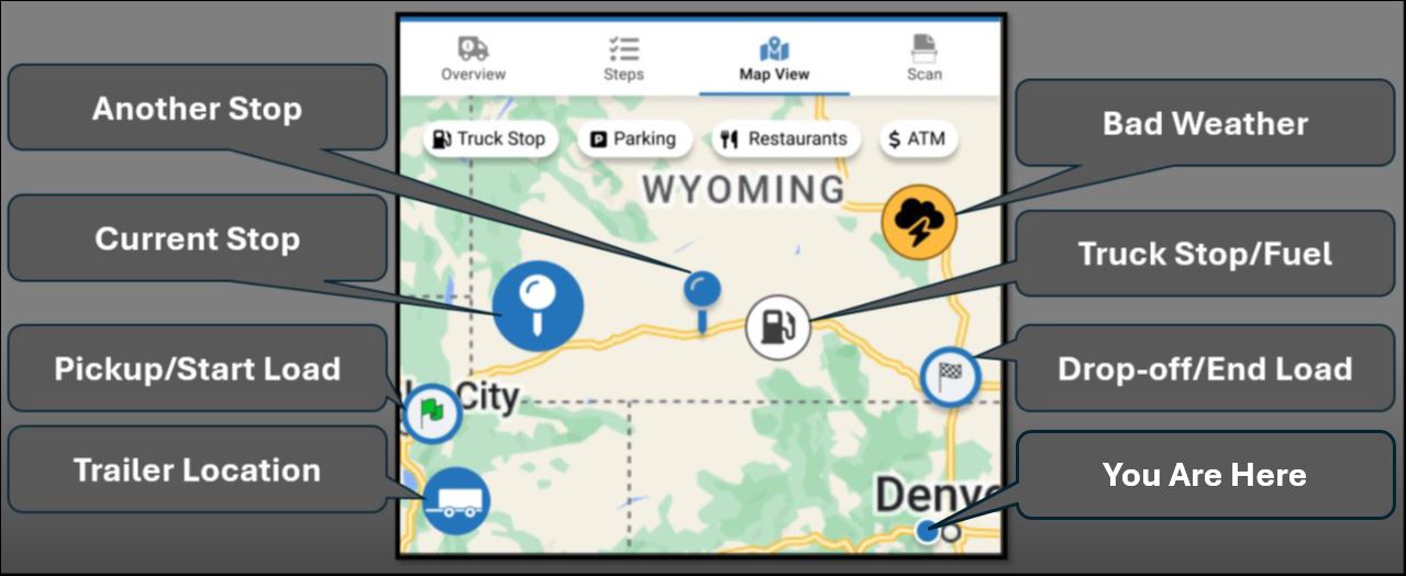
Map
Tap Map View to view the load stops and other points of interest on a re-sizable map. Weather and fuel locations are planned future features and might not be available on your actual maps at this time.
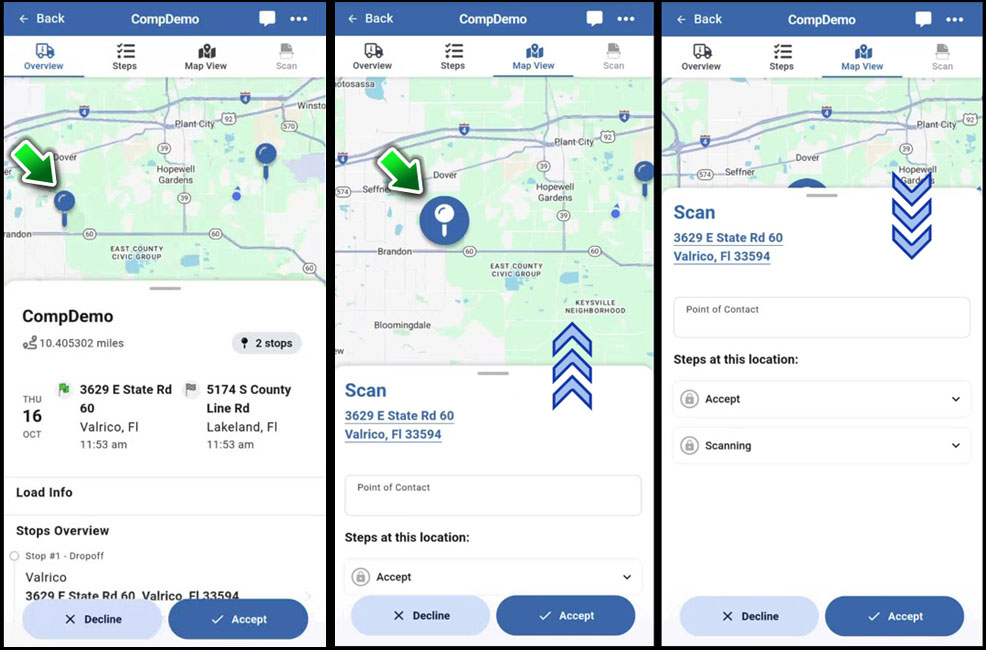
Example: Tap a stop to go to Map View.

This KB article describes new features under development in the 2025-2026 pre-release BETA edition of Transflo Loads Workflow 2.0. All KB articles are subject to change with or without notice and will be updated to align with future product development.
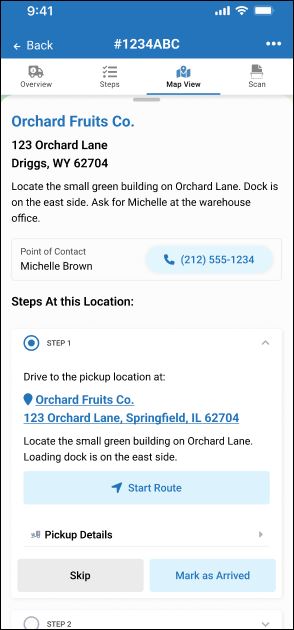
Open a load and tap the Map View tab at the top.
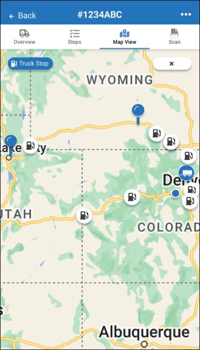
Tap one of the buttons along the top to show only those items. For example, tap Truck Stop, Parking, Restaurants, or ATM. The map shows the following items (features vary based on current location and your company setup):
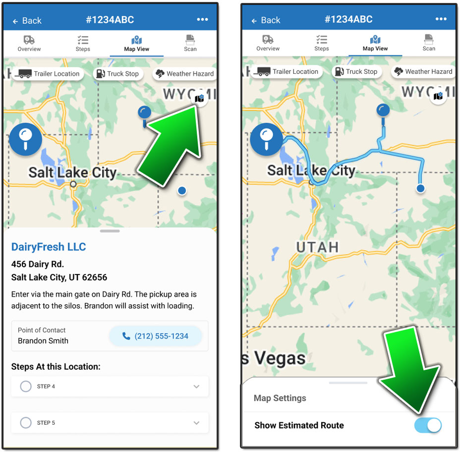
Load pick-up and drop-off locations including any mid-route stops
Estimated Route
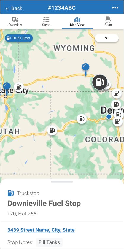
Truck Stops with Fuel
Restaurants
ATM Machines
Parking
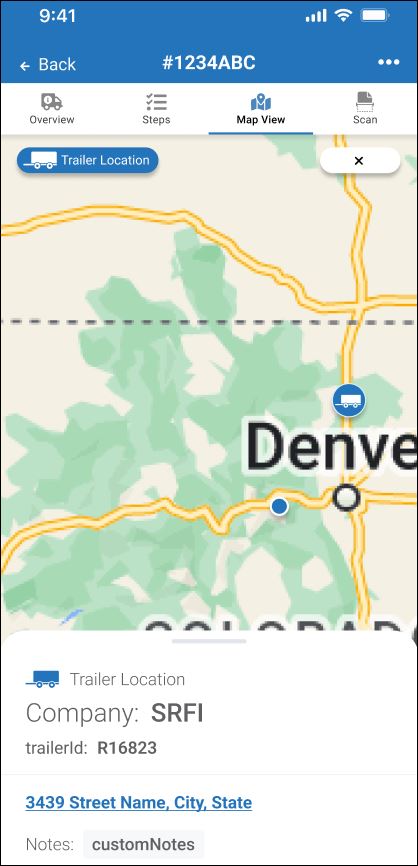
Last Known Trailer Location
Roads, cities, towns, topography, bodies of water, and major boundaries
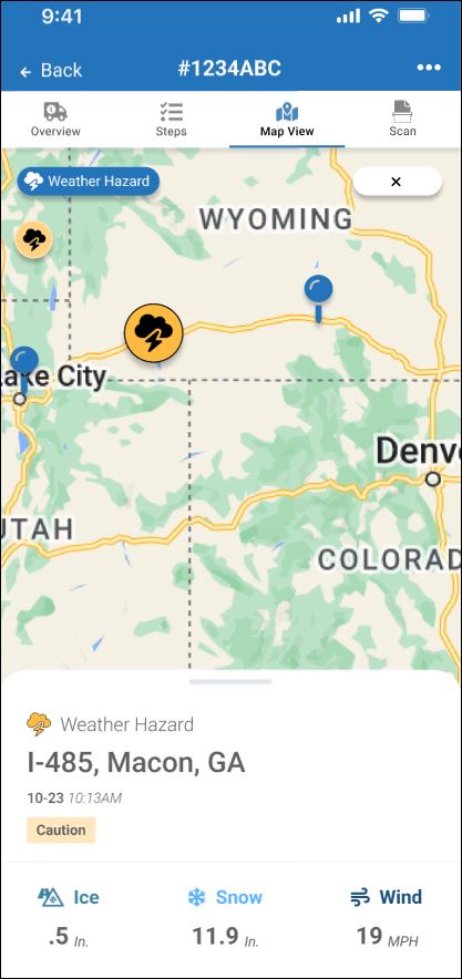
Hazardous Weather
To get more details, tap a specific item. For example, tap a single truck stop, trailer, or weather hazard.
Example A: Tap a weather hazard to view details about dangerous driving conditions such as wind, snow, or ice.
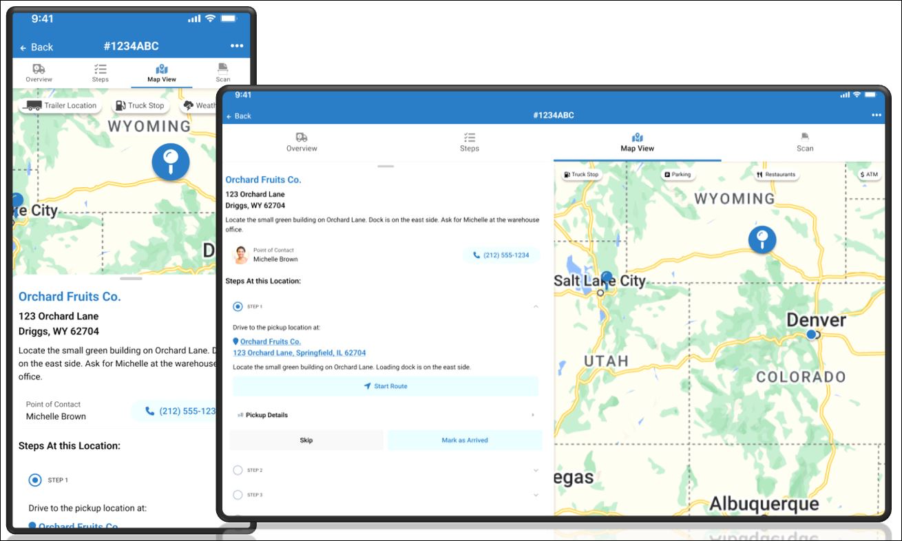
Example B: Tap a trailer to get its ID, street address, and view any important notes.
Example C: Tap a truck stop to get more info about it.
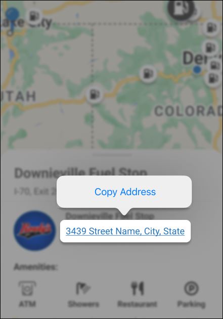
Example D: You can also view fuel station amenities such as showers, parking, restaurants (food), truck washes, and ATM cash machines. Follow the user guide for your operating system and device (Android, Samsung, Apple iOS, etc.) to copy the street address into your favorite map app for driving directions or just to save for your trip sheet.
When you are done viewing any specific items (for example, only fuel stations), tap X Close to go back to the standard map view.
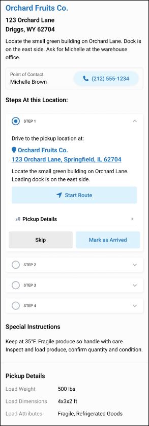
When you open the start (origination), middle stops, or end (destination) of a load in map view, scroll down to view more load details:
All steps appear (same as they appear on the Steps tab at the top).
If a telephone number appears, tap it to place a call (use a Bluetooth hands-free phone or stop and park before placing a phone call).
Tap any appropriate load status milestones, events, or action buttons. For example, Start Route or Mark as Arrived.
Keep scrolling down to view more details.
To see an estimated route that highlights possible roads to take from start to finish (including any middle stops),
Tap any stop on the route.
Tap Map Settings.
Turn ON the Show Estimated Route setting.

Was this help page helpful? To help us improve the documentation, click the Feedback... button at the top of this page and send us your praise or suggestions to make it even better.
 Yes (you found what you needed)
 No (you did not find what you needed)
Are you a carrier, broker, shipper, fleet manager, or 3PL administrator? Are you one of the 3.2 million professional drivers who rely on the Transflo Mobile+ app to deliver an average of 46+ million loads per year for 81 percent of the top 250 fleets and 80 percent of the top 10 freight brokers? As a leader in mission-critical automated supply chain solutions, Transflo processes over 4 million communications for carriers, shippers, and brokers each week, 52 weeks per year!
Transflo would love your feedback on our solutions and the support we provide to you!
Please take a moment to write a Google review about your experience with Transflo solutions, service, and support.
©2026 TRANSFLO®— a Pegasus Transtech Company
All rights reserved. Transflo believes the information in this publication is accurate as published; however, information is subject to change without notice. Use, copying, and distribution of any TRANSFLO software described in this publication requires an applicable software license. THE INFORMATION IN THIS PUBLICATION IS PROVIDED “AS IS.” TRANSFLO, LLC MAKES NO REPRESENTATIONS OR WARRANTIES OF ANY KIND WITH RESPECT TO THE INFORMATION IN THIS PUBLICATION, AND SPECIFICALLY DISCLAIMS IMPLIED WARRANTIES OF MERCHANTABILITY OR FITNESS FOR A PARTICULAR PURPOSE. Transflo makes this content available for your information only, as a courtesy. Transflo and its partners have made efforts to ensure the accuracy and completeness of the information in the available articles. However, Transflo makes no explicit or implied warranties of any kind with respect to this information. Transflo assumes no liability to any party for any loss or damage (whether direct or indirect) caused by any errors, omissions, or inaccuracies in the information, arising from your application or use of the information. As a convenience to users, the Google Translate API can be used to translate this information into languages other than English. Transflo and its partners assume no responsibility or liability for any errors or inaccuracies in any of these translations. Transflo content appearing in third-party AI chat bots and other third-party sites might not be accurate. For the latest updates about Transflo products, visit transflo.com and knowledge.transflo.com. Use subject to our privacy policy.